Why does anyone travel? To learn about our
world? To experience places and people different from our usual day-to-day
life? To see something new? To revel in the unique and beautiful? It turns out
you don’t have to travel all that far from home to experience amazing natural
beauty and unique natural marvels.
California is blessed with so many natural
landmarks that a list of the seven best is arguable. Let’s just agree that
these are seven, of many, captivating natural wonders you can visit in
California. Mother Nature does smile upon California time and time again. See
her in action at these incredible natural sights:
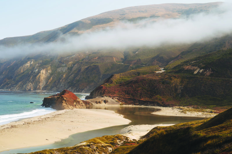
Big Sur
Highway 1 through Big Sur is located along the
Central Coast and is recognized as one of the crown jewels of the American
National Scenic Byway program. Best of all it is only a 6-hour drive from the
Santa Clarita Valley.
Along this beautiful stretch of coastal highway,
it is not unusual to see soaring California condors; migrating gray, humpback
and blue whales; and elephant seals. The area is renowned for windswept
Monterey cypress trees, brilliant sunsets, giant redwoods, crashing surf and
expansive views of the Pacific Ocean.
It is almost a rite of passage for a true
Californian to drive Highway 1. Landslides are a persistent problem along
Highway 1. It is currently open, but it is a good idea to check current
conditions at www.dot.ca.gov/hq/roadinfo/display.php?page=sr1.
Once you have arrived in Big Sur, earning your
“I Survived Highway 1” bumper sticker, be sure to see:
The ocean It’s important to keep your eyes on the road while driving so seek out
places to pull over so you can marvel at the magnificence of the waves crashing
against the rocky coastline.
The forests and
the parks Pfeiffer Big Sur State Park (hike through the
redwoods near the Big Sur River), Andrew Molera State Park (where you can visit
the California Condor Discovery Center) and Julia Pfeiffer Burns State Park (where
you can see stunning McWay Falls).
Info http://www.bigsurcalifornia.org
Castle Crags
Castle Crags is a dramatic and well-known rock
formation in Northern California. Elevations range from 2,000 feet along the
Sacramento River near the base of the crags, to more than 6,500 feet at the
summit of the tallest crag.
Located just west of Interstate 5, between the
towns of Castella and Dunsmuir, Castle Crags is today a popular tourist stop
along the highway.
Majestic Castle Crags has inspired enduring myths
and legends. More than 170 million years old, these 6,000-feet tall granite
spires in the Castle Crags Wilderness border the northwestern edge of Castle
Crags State Park.
Picnic sites are located along the Sacramento
River and at the awe-inspiring Vista Point.
Castle Crags State Park offers 28 miles of
hiking trails. There is a hike suitable for all abilities. From the Vista Point
parking area, a quarter-mile accessible trail leads visitors to Vista Point,
where there are dramatic views of Castle Crags, Mount Shasta and nearby Grays
Rocks. Gentle and shaded, the mile-long Root Creek Trail guides hikers along an
accessible path to a year-round flowing creek.
The most popular and challenging route is the
Crags Trail, which leads adventures to the base of Castle Dome to experience
breathtaking views. The Pacific Crest Trail winds through the park as well.
Info www.parks.ca.gov/?page_id=454
Crystal Cave,
Sequoia National Park
Underneath Sequoia National Park lies a
little-known wonder. Crystal Cave, a marble karst cave with more than 3 miles
of passages, is a treasure of ornate marble polished by subterranean streams
and decorated with curtains of icicle-like stalactites and mounds of
stalagmite.
It is a secret underground world, a landscape of
glittering mineralogical features. And, it is one of 240 known caves in Sequoia
National Park.
Located about a 40-minute drive south of
Wuksachi Lodge near Giant Forest in Sequoia National Park, Crystal Cave is
available for exploration during the summer months only. It’s about 50 degrees
inside Crystal Cave no matter what the temperature is outside.
Tours now through Sept. 29 include:
Family Tour: 50-minute tour for all ages.
Thirteen and Older Tour: 50-minute tour.
Discovery Tour: 1 1/2 hours for ages 13 and up.
Wild Cave Tour: 4-6 hours for ages 10 and up,
participants must be in good physical condition to participate.
Family Caver Tour: 2.5-hours for ages 10 and up,
and expect to get dirty.
Crystal Cave is run by the Sequoia Parks Conservancy.
Info
www.visitsequoia.com/explore/tours/crystal-cave
Lava Beds
National Monument
Located in northeastern California, in Siskiyou
and Modoc counties, the monument lies on the northeastern flank of the Medicine
Lake volcano.
For the last half-million years, volcanic
eruptions on the Medicine Lake volcano have created a rugged landscape dotted
with diverse volcanic features. More than 700 caves, Native American rock art
sites and a high desert wilderness experience await visitors.
Perhaps the most exciting part of this expansive
and “wild” park are the lava tubes. The lava tube caves were created by flows
of smooth lava 10,500 to 65,000 years ago. As the lava flowed, it began to cool
and solidify on the top and sides. Once the eruption ceased, the tube emptied
and drained and a new lava tube cave was left behind.
The Lava Beds Monument was established as a
United States National Monument on Nov. 21, 1925.
Info www.nps.gov/labe/index.htm
Natural Bridges
Trail
The Natural Bridges trail in the Vallecito area
of Calaveras County is a beautiful 2-mile round-trip hike that leads you to
spectacular limestone caverns.
Maintained by the US Bureau of Reclamation the
trail can be accessed by visiting the Natural Bridges Day Use Area off Parrotts
Ferry Road. This scenic tunnel was carved out by Coyote Creek as it flowed to
New Melones Lake. Walk through a forest of oak trees on your way to the caverns
which feature oddly shaped formations hanging from its roof.
Best of all, this beautiful, natural cave, is
free to visit. It is 250 feet from one end of Natural Bridges to the other.
Once inside, the cave opens up into a huge vaulted ceiling. Water flows through
the cave year-round and even in summer it is cold, so come prepared.
The lower entrance to the cave is the most
family friendly with plenty of places to enjoy a picnic. Bring a change of
clothes and shoes for walking in water.
Info
www.gocalaveras.com/travel-directory/natural-bridges/
Mt. Shasta
Soaring to 14,179 feet, Mt. Shasta is a magnificent
dormant volcano that seems to scrape the sky north of Redding. The mountain
last erupted in 1786.
Visible through much of Northern California, the
mountain is a vision of beauty when clad in its coat of winter white. It rises
from surrounding flatlands in such perfect, cone-shaped, snow-capped majesty
that it seems almost unreal.
The best way to get up close and person with Mt.
Shasta’s beauty is to take the Everett Memorial Highway up to Bunny Flats. You
can explore wildflower covered meadows and short, easy hikes during the summer
months. In the winter, it is a snow activity area.
The Mount Shasta
Wilderness is a 38,200-acre federally designated wilderness area located 5
miles east of Mt. Shasta City. The wilderness was created by Congress when it
passed the 1984 California Wilderness Act.
Info www.fs.usda.gov/stnf/ or www.fs.usda.gov/recarea/stnf/recarea/?recid=6575
Vasquez Rocks
Last, but not least, is Vasquez
Rocks Natural Area. The park, located so close to home you don’t need to get a
hotel room, features 932 acres of spectacular rock formations and a seasonal
stream.
Vasquez Rocks was formed in
prehistoric times when the sandstone rocks were uplifted at a picturesque
angle, showing their jagged red features. In 1874, Tiburcio Vasquez, one of
California’s most notorious bandits, used this area as a hideout to elude
capture by the law.
Besides that claim to fame, the
uniqueness of this geologic formation brings geologists from across the globe
to study these unusual “rocks.” The beauty and “alien” look of Vasquez Rocks
has made the area a favorite for television, movies and commercials.
Most notably, the area was the
scene of the battle between Captain Kirk and the Gorn in the original “Star
Trek” series and the location used in the live-action “The Flintstones” film,
among hundreds of others.
Vasquez Rocks Natural Area and
Nature Center is located at 10700 W. Escondido Canyon Road, Agua Dulce.
Info
http://parks.lacounty.gov/vasquez-rocks-natural-area-and-nature-center/#