In Stanislaus County, people of different political stripes sympathize with the need for more water storage for thirsty farms.
But a plan for a reservoir in Del Puerto Canyon west of Patterson was bound to touch a nerve.
To many West Side residents and others familiar with the site, Del Puerto Canyon is a natural gem and one of the county’s scenic wonders.
An environmental impact report released last week raises some concerns about seismic risks and impacts on wildlife. But a significant and unavoidable impact noted in the report is “substantial damage to scenic resources,” “degradation of the visual character” and “adverse effect on a scenic vista.”
“On the West Side, we don’t have many places to get out in nature,” said Shivaugn Alves of Patterson.
Alves said the canyon, colored by blue oaks and more than 100 species of birds, is a natural respite for community members. The earthen-fill dam just west of Interstate 5 would put much of the lower canyon under water.
Alves, whose family are almond growers, said she recognizes the need for water storage, and she is not “anti-dam.” She is co-founder of the Patterson Progressive Alliance, which posted an online petition signed by more than 100 people, urging careful and considerate planning for the $500 million project.
The petition says, in part, that as the population grows in Patterson and development occurs in the city of 23,750 residents, there are few natural spaces for residents. A recreation area at the reservoir could provide biking and hiking trails, fishing, paddling and other activities, the petition says.
A museum could also feature exhibits on the canyon’s American Indian heritage.
The Del Puerto Water District, the leading proponent for the reservoir, has also received letters from nature enthusiasts from the Bay Area and the eastern side of the county.
“I believe there are significant recreational impacts,” John Harris of Oakdale wrote. “Del Puerto Canyon is used by people throughout central California as a site for nature observation and photography.”
The water district and partners in the San Joaquin River Exchange Contractors Water Authority want the reservoir to improve the reliability of deliveries from the Central Valley Project, a massive system of dams and canals that supplies water to San Joaquin Valley farmers.
The politics of pumping water south from the Sacramento-San Joaquin Delta often results in severe cuts to CVP contractors. Up to 85,000 acre-feet of water pumped from the Delta-Mendota Canal would create an 800-acre lake in wet years and be released for use in dry years.
The draft environmental study by Woodard & Curran of Walnut Creek predicts the dam would experience ground shaking during its 100-year lifespan, due to earthquakes in the broader region. While the reservoir site is not in a recognized fault-rupture hazard zone under the Alquist-Priolo Act of 1972, there are two active faults within 20 miles, the study says, including the Great Valley/Orestimba Fault just east of the dam.
The proponents say the California Department of Water Resources division of dam safety must approve a design and construction plan and will require a seismic hazard analysis. The design will need to ensure that the dam, grounded in bedrock, remains stable in an earthquake, that seepage is managed and that spillway capacity is adequate, the EIR says.
The report also suggests the reservoir could lead to ground subsidence and landslides in the canyon.
Chris White, executive director of the San Joaquin River Water Authority, said the study identifies seismic issues that can be addressed by engineers who design the dam.
“Our project designers have not indicated this is something that can’t be designed,” White said.
The water districts are talking with the city and county leadership about recreation opportunities.
“There are some good ideas,” White said. “It is not our area of expertise, but the county and city do have that expertise in recreation. It would be a separate project taken on by the county and city with the districts’ cooperation.”
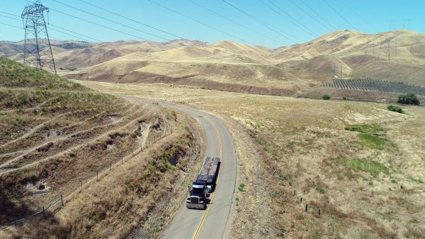
The districts are responsible for realigning Del Puerto Canyon Road, part of which would be covered by the reservoir, so the public still has access to Frank Raines Park and an off-road vehicle area. The EIR’s section on aesthetic resources mainly refers to altering the view from a section of Interstate 5 that’s a scenic highway.
People out for a bike or motorcycle ride on Del Puerto Canyon Road are mostly enjoying a view of private ranches at the 800-acre reservoir site. Alves said that property owners who would sell land for the reservoir said at a workshop last week that any recreation should come at public expense.
Alves said residents attending the workshop were not given answers about the flood path of a dam failure or whether they will need to buy flood insurance.
The environmental study also predicts some glare and light pollution, which can be mitigated by adjusting the lights to the dam control building and facilities.
Air emissions would increase during construction of the dam, and the pumping of Delta-Mendota water would indirectly put greenhouse gases in the atmosphere, the study says.
An alternative reservoir site in Ingram Canyon, seven miles to the north, would produce twice the amount of greenhouse gases that contribute to climate change. The alternative site would mean less impact from construction vehicles on the I-5 and Sperry Road interchange but more traffic for the I-5 and Howard Road turnoff.
Rather than inundate a scenic canyon, some suggest that groundwater banking and conservation measures by irrigation districts could increase water supplies for agriculture at far less expense.
“I was quite dismayed to hear about the (dam) proposal,” Garry Hayes, a Modesto Junior College geology professor, wrote in an email. “Del Puerto is a geological and natural treasure. … I think the (environmental study) is understating the landslide risk.”
Hayes also questioned if the study took into account a dinosaur fossil discovery on a hill just above the proposed reservoir level.
As the dam proponents consider a new route for Del Puerto Canyon Road, Chris Stovall of Patterson, in a letter to the water district, suggested that transportation planners consider punching a highway through the Diablo Range to the south Bay Area.
“As I’m sure you know, the Altamont Pass is massively undersized for the amount of traffic it sees on a regular basis,” Stovall wrote. “This area needs another freeway connecting it to the Bay Area.”
County Supervisor Jim DeMartini said parks and recreation staff are considering locations for bird-watching, camping and other activities., but boating is likely ruled out because the water level would fluctuate.
“I think it’s a good place for storing water,” the supervisor said. “The water districts don’t have anyplace to store water when they get it. It would be a great benefit for them.”
Comments on the EIR can be made at a public meeting from 4 p.m. to 6 p.m. Jan. 15 at the Hammon Senior Center, 1033 W. Las Palmas Ave., in Patterson. Written comments will be accepted until Jan. 27 at Del Puerto Water District, 17840 Ward Ave., Patterson 95363.